Public Archive
A patchy record of DIY satellite imagery and weather notes since 2020. The open-weather public archive is open to everyone willing and able to contribute.
Words for Climate
An evolving set of words chosen by contributors to reflect their experiences of the climate crisis.
Filter by
Ground Station Type
Automatic Ground Stations are local, semi-permanent stations that record and upload satellite transmissions automatically once per day. Manual ground stations are DIY and often mobile; operators manually record and upload satellite transmissions.
Satellites
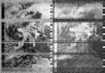
The archive contains Automatic Picture Transmissions (APT) by US weather satellites NOAA-15, NOAA-18 and NOAA-19.
Nowcasts
Collective earth-sensing events led by open-weather, co-produced by a network of contributors around the world.
Contributors
A list of tagged contributors only. Please contact us if you want to be added.
Automatic Ground Stations
Search
2587 archive entries
2025-08-31 22:14:00
Diana Engelmann
Filip Shatlan
Gainesville, Florida , United States
United States
NOAA-19
2025-08-31 17:10:00
Nastassja Simensky
Longyearbyen, Svalbard
Svalbard
NOAA-15

2025-08-31 10:55:00
Diana Engelmann
Filip Shatlan
Gainesville, Florida , United States
United States
NOAA-19

2025-08-31 10:05:00
Oppressive Heat Project
Phnom Penh, Cambodia
Cambodia
NOAA-19

2025-08-30 18:53:00
Oppressive Heat Project
Phnom Penh, Cambodia
Cambodia
NOAA-15

2025-08-30 10:57:00
Nastassja Simensky
Longyearbyen, Svalbard
Svalbard
NOAA-15

2025-08-29 21:40:00
Oppressive Heat Project
Phnom Penh, Cambodia
Cambodia
NOAA-19

2025-08-29 08:59:00
Diana Engelmann
Filip Shatlan
Gainesville, Florida , United States
United States
NOAA-15
2025-08-29 13:42:00
Nastassja Simensky
Longyearbyen, Svalbard
Svalbard
NOAA-19

2025-08-28 22:53:00
Diana Engelmann
Filip Shatlan
Gainesville, Florida , United States
United States
NOAA-19
2025-08-28 11:33:00
Diana Engelmann
Filip Shatlan
Gainesville, Florida , United States
United States
NOAA-19
2025-08-28 13:55:00
Nastassja Simensky
Longyearbyen, Svalbard
Svalbard
NOAA-19

2025-08-28 07:03:00
Oppressive Heat Project
Phnom Penh, Cambodia
Cambodia
NOAA-15

2025-08-27 19:09:00
Nastassja Simensky
Longyearbyen, Svalbard
Svalbard
NOAA-19

2025-08-27 18:32:00
Oppressive Heat Project
Phnom Penh, Cambodia
Cambodia
NOAA-15

2025-08-26 23:17:00
Diana Engelmann
Filip Shatlan
Gainesville, Florida , United States
United States
NOAA-19

2025-08-26 08:37:00
Diana Engelmann
Filip Shatlan
Gainesville, Florida , United States
United States
NOAA-15

2025-08-26 18:58:00
Oppressive Heat Project
Phnom Penh, Cambodia
Cambodia
NOAA-15

2025-08-26 11:02:00
Nastassja Simensky
Longyearbyen, Svalbard
Svalbard
NOAA-15

2025-08-25 20:17:00
Diana Engelmann
Filip Shatlan
Gainesville, Florida , United States
United States
NOAA-15

2025-08-25 19:35:00
Nastassja Simensky
Longyearbyen, Svalbard
Svalbard
NOAA-19

2025-08-25 09:03:00
Diana Engelmann
Filip Shatlan
Gainesville, Florida , United States
United States
NOAA-15

2025-08-25 09:41:00
Oppressive Heat Project
Phnom Penh, Cambodia
Cambodia
NOAA-19

2025-08-24 20:44:00
Diana Engelmann
Filip Shatlan
Gainesville, Florida , United States
United States
NOAA-15
2025-08-24 22:46:00
Oppressive Heat Project
Phnom Penh, Cambodia
Cambodia
NOAA-19

2025-08-24 16:53:00
Nastassja Simensky
Longyearbyen, Svalbard
Svalbard
NOAA-15

2025-08-24 09:31:00
Diana Engelmann
Filip Shatlan
Gainesville, Florida , United States
United States
NOAA-15

2025-08-24 09:53:00
Oppressive Heat Project
Phnom Penh, Cambodia
Cambodia
NOAA-19

2025-08-23 22:15:00
Diana Engelmann
Filip Shatlan
Gainesville, Florida , United States
United States
NOAA-19

2025-08-23 23:00:00
Oppressive Heat Project
Phnom Penh, Cambodia
Cambodia
NOAA-19

2025-08-23 17:19:00
Nastassja Simensky
Longyearbyen, Svalbard
Svalbard
NOAA-15

2025-08-23 08:16:00
Diana Engelmann
Filip Shatlan
Gainesville, Florida , United States
United States
NOAA-15

2025-08-23 10:06:00
Oppressive Heat Project
Phnom Penh, Cambodia
Cambodia
NOAA-19

2025-08-19 19:36:00
Centre for People, Place and Planet (AU)
Perth, Australia
Australia
NOAA-15


Too attached to 15/19/18...was so sad to see only static noise images. That was it (for now?).
2025-08-22 19:56:00
Diana Engelmann
Filip Shatlan
Gainesville, Florida , United States
United States
NOAA-15
2025-08-22 08:43:00
Diana Engelmann
Filip Shatlan
Gainesville, Florida , United States
United States
NOAA-15
2025-08-22 08:37:00
Heidi Neilson
Gilboa, New York, United States
United States
NOAA-15

2025-08-22 19:03:00
Oppressive Heat Project
Phnom Penh, Cambodia
Cambodia
NOAA-15

2025-08-22 11:07:00
Nastassja Simensky
Longyearbyen, Svalbard
Svalbard
NOAA-15

2025-08-21 11:39:00
Zack Wettstein
Seattle, United States
United States
NOAA-19

2025-08-21 09:04:00
Heidi Neilson
Gilboa, New York, United States
United States
NOAA-15

2025-08-21 13:43:00
Nastassja Simensky
Longyearbyen, Svalbard
Svalbard
NOAA-19

2025-08-20 19:34:00
Zack Wettstein
Seattle, United States
United States
NOAA-15

2025-08-20 19:10:00
Heidi Neilson
Gilboa, New York, United States
United States
NOAA-15

2025-08-20 11:52:00
Zack Wettstein
Seattle, United States
United States
NOAA-19

2025-08-20 08:14:35
Steve Engelmann
Santa Monica, California, United States
United States
NOAA-15


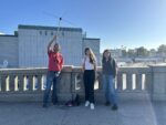
Today NOAA-15 was flying over with an 86° elevation. From recent posts on Open-Weather I was prepared for what I might receive, but I thought I would try regardless. As I was watching the sun rise over Santa Monica, we were witnessing the sunset of NOAA-15. But with any reputable seance it was a communal gathering. Several of my students joined me and persisted through 8 minutes and 34 seconds of static. NOAA-15, 18 and 19 shall live in my dreams.
2025-08-20 16:58:00
Nastassja Simensky
Longyearbyen, Svalbard
Svalbard
NOAA-15

2025-08-19 20:14:04
Sasha Engelmann
Donostia / San Sebastián , Spain
Spain
NOAA-15

NOAA-15
You were launched
on a Wednesday in 1998
on a rocket called Titan
impossible heat
fuelling an ascent
into low earth orbit
Your launch site
named after an air force general
was 15 minutes’ drive
from the town ‘Lompoc’
or, for Chumash peoples
lumpo’o̥
‘in the cheeks’
where placenames
are bodies
When you entered space
I was nine
playing soccer
in Lompoc County
skinny legs
trying and failing
to curl a ball into a net
You fell silent
on a Tuesday in 2025,
impossible heat
raging in wildfires below
a night-moth beat the air
swirling particles
I know it’s ’empty’
but I listen to your frequency
cold static
filling a void
of recognition
2025-08-19 21:53:00
Zack Wettstein
Seattle, United States
United States
NOAA-19

2025-08-20 06:05:00
Maufox
Mauritius, Mauritius
Mauritius
NOAA-15

2025-08-20 07:12:00
Oppressive Heat Project
Phnom Penh, Cambodia
Cambodia
NOAA-15

2025-08-19 19:36:00
Heidi Neilson
Gilboa, New York, United States
United States
NOAA-15

Although I was prepared for it, it is still such a bummer to find an empty static grey where an image should be. RIP POES satellites! You are missed.
2025-08-19 08:37:00
Zack Wettstein
Seattle, United States
United States
NOAA-15

2025-08-19 18:56:00
Maufox
Mauritius, Mauritius
Mauritius
NOAA-15

2025-08-19 09:52:56
Richard A Carter
York, United Kingdom
United Kingdom
NOAA-15

Endings are always messy – only in fiction can they be tied up neatly and beautifully, following a clear, timetabled arc towards a point where all actions are resolved, accompanied by a pithy epilogue that captures it all with suitable profundity. This time last week was meant to be the end of NOAA 15, and yet I nonetheless manage a recording this morning. I was not going to do so, but a brief glance at a Facebook group suggested that today is indeed the day that NOAA 15 will, at long last, be shut down. If the timings are true, then this morning’s pass over Europe will be the very final one. Breakfast in hand, I race to set up the antenna and make an IQ recording, a minute or two into the pass. It has rained, very softly, during the night, and the cool grey air feels more like mid-September – matching the appearance of the foliage around me. I am glad for the rain, but it is, of course, nowhere near enough to make up for this desiccating summer weather. I can still smell smoke from the ongoing Langdale fire.
I am not a good writer, and I am not good at beautiful, thoughtful expression more broadly. No great poetry flows from my pen – though, I also admit, I am sometimes wary of the idea that it should be sought after, for it can belie situations that are far more quotidian, and are actually best recorded as such. The reality is that I was rather irritated with having to rapidly assemble my clumsy antenna, hook everything up, and try to record the pass amidst the damp and the overall rush of my morning routine. The antenna fell over twice, and I had to keep wiping the drizzle off my computer. I had nowhere near enough focused energy to meditate as the moment felt like it deserved, and instead I hurriedly finished the recording, disassembled my equipment, and with mild relief got back to the dozen or so tasks ahead of me – none of which have any significance at all, but which needed doing. Endings invariably happen at inconvenient times, rarely making their presence known predictably beforehand, and trying to offer a capstone statement amidst the flow of time can too readily underplay the mess of the actual moment.
What else is there to write, then? Perhaps the Facebook post was wrong – maybe NOAA 15 will ring out later today, perhaps even tomorrow? I suspect not – the declared timings make sense. In any case, the closeout of NOAA 15/18/19 does not, of course, mark the end of weather observations from space – there is a veritable zoo of orbital artefacts that are diligently staring at the transforming Earth. I am currently investigating the costly challenge of trying to record some of their signals – a shift in technology and practice that mirrors worldly shifts in computing more broadly, from the faintly miraculous sound of the analogue APT downlink, and all the quirky openness it invites, to the much more slick, stratified, and expensive regimes required to interface with contemporary satellite systems. The latter are so much more capable, but are vastly more forbidding, and offer fewer windows for non-professional users to access them, whether for science or indeed art. The digital environment these satellites now feed into has so much more data coming through overall, underpinned by sprawling data centres, supercomputer clusters, and AI routines, but my sense is that it is not a richer or better place for it.
I have now packed the antenna away in my office on campus. I won’t be trying again to listen to NOAA 15, absent of any 'official' confirmation of its impending shutdown. Ultimately, short of a contingency (like last week, in fact), this morning has been enough for me, and enough for this practice. It is not the technology that I am invested in, but the world that it records, and that still turns anew. Writing this at my desk, I am thinking now of all the weather that I have observed both below and amidst. I am thinking of how every moment of my life has been shaped and shifted by the presence of processes far beyond my minuscule registers of being. I think of what it means to “be” in this ocean of air, and what it means to attend to it. Weather satellites are instruments for paying attention, for trying to parse the flows of the Earth into markings and then into signs – a language all of its own. I am reflecting on how indeed everything can be read: every flow and every eddy and every sigh of wind and rain and cloud, every flare of sunlight and pall of haze, every thermal and every wave bar, every ripple of energy running through every leaf in every rustling tree. There are signals and signs all around, and I shall be listening and watching – to know them is to know one is alive in the world.
2025-08-19 11:29:34
Alison Scott
Hospitalfield, Arbroath, United Kingdom
United Kingdom
NOAA-15

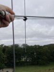
After the pass earlier this morning I sat on the tower for some time, listening to the birds, writing my weather note. Looking at the images, I often feel it's strange how my ears can filter so much of the static: I could hear NOAA-15 for much longer than the image might suggest. Watching the pips of yellow on CubicSDR's waterfall display, it was clearly weaker than I was expecting. I'm left wondering if it was the effect of the antenna, or if the satellite was starting to power down. Ross appears from the small blue door at the top of the spiral staircase. We figure we might as well take down the v-dipole from the balustrade, and unwind the RF cable from the staircase. When that's done it's not long until this pass. Ordinarily I wouldn't bother with such a low pass (usually saying 'it'll come back around') but I decide to have one last listen with the turnstile to say farewell to NOAA-15.
NOAA-15 is coming from the north, reaching a max elevation of 13 degrees to the north west, which is pretty much exactly where the lightning rod is. So between that and the previous image my expectations are low for clarity, but that's not and is never the point. After the joys and buzz of passes on the beach with friends and the summer festival, being up here alone feels peaceful. I'm happy to pick up an intermittent signal amid the noise, moving my body with the trajectory of the satellite, searching with the antenna for one last time.
On my way out I chat to the Hospitalfield team about endings, archives, and memory – and although there will be no new images from these satellites, still orbiting silently, there's lots of reflection to come.
2025-08-19 09:51:32
Alison Scott
Hospitalfield, Arbroath, United Kingdom
United Kingdom
NOAA-15

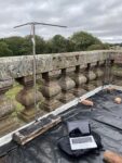
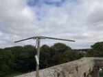


It's overcast. On the way up the drive I bump into Ross mowing. Just the edges, the long grass and wild plants are left to grow, turning to seed. Leaves on trees looking just a little past their best. He says it's early, this turn to the autumnal.
Up on the tower I can see him and another person down below working near the greenhouse. In the other direction there’s just a thin line of sunlight bouncing off the horizon out at sea. The wind is lightly rippling the puddles in the tarp on the roof. I haven't been up here for a while. The antenna has lost its gleam, tarnished after its months exposed to weather.
I check the setup is working by drifting through the radio spectrum. I land on what I find out is radio north Angus. The presenter likes to play music by local musicians only. Montrose born and bred etc. She says we need to shout about Angus more. She says, Angus is probably not well known unless you're in the potato trade. I laugh and re-tune to 137.62 megahertz.
I'm sitting cross legged on the tarp on top of the roof, my laptop is nestled on top of my laptop. The antenna here hasn't been receiving for a month or so - since the AGS stopped working with the WiFi and it proved hard to fix. Instead I've plugged the set up I use manually into the v-dipole. I feel like I'm sitting listening - statically - to the ‘static’ for ages, I'm used to holding and moving around with the antenna. It feels quite solemn. I hear the faint beeps and expect the sound to burst into full rhythm - butt it remains faint amid the noise. It really feels like NOAA-15 is fading out.
After I decide I won't hear any more of the pass I sit up on the tower for a bit with the static ringing in my ears. While I've been sitting still, I've been thinking of all the places I've taken my turnstile antenna to and listened to these satellites. The familiar sound has been a sort of rooting wherever I’ve ended up. A sort of constant. I've listened in fields, beaches, leaning out of windows, at old observatories, in parks and some spots I'm sure I'm forgetting. In the day and in the night. Here, I think again of the telescope down in the store room that is thought to have been used on the tower in the Victorian period. Shifting technologies, shifting time, people, but perhaps something connected. I look up, squinting. The sun bursts through cracks in the cloud, bringing me back into the day.
2025-08-19 18:42:00
Oppressive Heat Project
Phnom Penh, Cambodia
Cambodia
NOAA-15
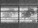
2025-08-19 10:45:00
Nastassja Simensky
Longyearbyen, Svalbard
Svalbard
NOAA-15

2025-08-18 19:21:38
Soph Dyer
Augarten, Wien, Austria
Austria
NOAA-15
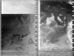

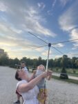
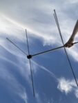
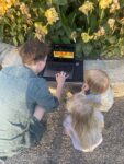
Adult: "What are you waiting for?"
Child: "Outer space!"
2025-08-18 22:06:00
Zack Wettstein
Seattle, United States
United States
NOAA-19

2025-08-14 09:49:00
Centre for People, Place and Planet (AU)
Perth, Australia
Australia
NOAA-19


Receiving yet again white noise. The fabric of reality feels like clouded in white noise. We will miss you NOAA-19.
2025-08-19 06:30:00
Maufox
Mauritius, Mauritius
Mauritius
NOAA-15

2025-08-18 09:40:19
Sasha Engelmann
Zumaia, Spain
Spain
NOAA-15
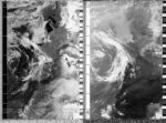
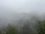
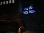

On the phone earlier today, T's mom asks if we have been affected by the fires in Spain. For us, looking out the window into a salty, oceanic cloud, fire could not seem farther away. Yet a quick news search reveals that for the past few days, while we have been avoiding most news media on holiday, wildfires have been raging across Northwest Spain, driven by a heatwave that has seen temperatures reach over 45 degrees Celsius in many regions. The Basque Country appears protected by the Cantabrian and Basque Mountains, which extend westward from the Pyrenees.
This year alone, about 343,000 hectares (847000 acres) have burned across Spain, according to the European Forest Fire Information System (EFFIS) - close to double the amount from the last year. '40,000 acres' is still etched into my mind from watching my home neighourhood burn in the LA Fires of January this year. I choose not to look up how many acres have burned in California this year, as I fear the number would rival that of Spain.
In a monastery at the top of a mountain, I notice a repeated four-part symbol, and learn that it represents the four elements, and is a symbol of the Basque Country more widely, found in myth and spiritual traditions. Each of the four elements had a representative female goddess. Mari, the goddess of earth whose story predates Christianity, is the most powerful of the four. Walking along clay-rich trails, along humid ravines and against cliffs, this makes intuitive sense, here.
2025-08-18 19:23:00
Nastassja Simensky
Longyearbyen, Svalbard
Svalbard
NOAA-19

2025-08-18 09:04:00
Zack Wettstein
Seattle, United States
United States
NOAA-15
2025-08-18 19:22:00
Maufox
Mauritius, Mauritius
Mauritius
NOAA-15

2025-08-17 18:50:21
Alison Scott
East Haven, Angus, United Kingdom
United Kingdom
NOAA-15
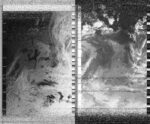
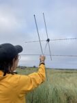
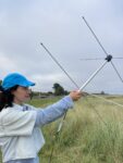
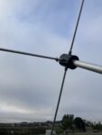
It's been another hot day. We cycle along the coast from Arbroath to East Haven beach as a group of four, grateful for the breeziness. I'm bringing the antenna with me to make the most of this borrowed time NOAA-15 has been having, and with company keen to listen. The sky gets cloudier as we arrive, just as most people are leaving the beach, dragging paddle boards and picnic blankets away. Here we meet another pair, who quickly get caught up in hearing about NOAA-15's imminent pass. The tide is quite far out, but on it's way back in, and we've got time for a quick and quiet swim. I was in the sea closer to the town this morning at high tide, when the sun was stronger, floating ontop of the salty water and squinting with the glints catching on the waves. The water is warmer and darker for this evening's dook, or it's the effect of the air feeling cooler in comparison. We hear curlews, oyster catchers and gulls, and as I emerge from diving under am fooled by my friends joking they saw a dolphin. The sea is pretty clean with flecks of sea lettuce, laver and gutweed floating (I think: I've been trying to get better at identifying seaweeds). East Haven was first recorded as 'Stinchendehavene' in 1214, also known as Stink Haven, I believe on account of the stench of rotting seaweed. These days it's well looked after by a local environmental group. We emerge from the water in various states of cold - one person has Raynaud's syndrome that effects their hands, another is prone to catching the shivers. We layer up and share a few snacks, in Scotland this is called a 'chittery-bite' or a 'shivery-bite': something small and sweet to stop your teeth chattering. Back on the dunes we set up our ground station, seeing what local radio we can pick up before NOAA-15 is due to arrive. We bop to some dance tunes, maybe on Tay FM, find Radio 2 and a few unknown channels: one broadcasting dour Christian sermons, the other a radio play. Pointing the antenna out to sea NOAA-15 comes in, and we pass the antenna between four pairs of keen (and cold) hands. The other two are content with watching and listening, chatting and laughing among the group's glee. A wasp lands on the antenna and stays a while. It's a long pass, the sky wide and open. With it's end our group disperses, most are cycling onward to Dundee. Aaron and I turn back to Arbroath, into a bit of a headwind as a thick haar comes down over the town ahead of us. Rabbits dash out in the fields as they hear us coming, and small birds emerge from the gorse that narrows the path.
2025-08-18 08:42:00
Heidi Neilson
Gilboa, New York, United States
United States
NOAA-15
2025-08-18 19:08:00
Oppressive Heat Project
Phnom Penh, Cambodia
Cambodia
NOAA-15
2025-08-17 22:19:00
Zack Wettstein
Seattle, United States
United States
NOAA-19

2025-08-18 06:56:00
Maufox
Mauritius, Mauritius
Mauritius
NOAA-15

2025-08-17 19:13:00
Zack Wettstein
Seattle, United States
United States
NOAA-15
2025-08-17 19:29:33
Birbie
Madison, United States
United States
NOAA-15

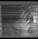
The last transmission of NOAA 15, Thank you for 24 years of service!
(my father asked me about there is no clouds in the sky, i told him that the satellite is going to be decommissioned tomorrow)
2025-08-17 18:52:00
Richard A Carter
York, United Kingdom
United Kingdom
NOAA-15

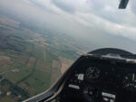

This weekend has been marked by eco-anxiety. There have been news reports that this summer could well be the driest on record for the UK, and the tinder-box conditions have resulted, here in Yorkshire, in a devastating fire across Langdale Moor (part of the wider North Yorkshire moorlands). 5 sq. km in size, ecologists have mourned the terrible losses in wildlife and vegetation it has inflicted, warning us that it could take decades, centuries, even millennia to fully recover what has been lost. Time I rather suspect it will not have.
Smoke from the fire has been hanging low over the city of York, around 35 miles away. It has affected atmospheric visibility significantly, shifting the late summer light into a deeper band of gold - more akin to what I expect in early Autumn. On that point, I've noticed the leaves are turning brown and berries and apples are ripening rapidly, which is another sign of the ecological stresses caused by this relentlessly dry summer.
My flight on Saturday was marked initially by some poor visibility - the photo provided has been cleaned significantly, but the conditions at height were noticeably dark. This was a clear result of the rising smoke from the fire - looking in the direction of the moor from launch height at 2,500ft, I could not see anything at all, other than a thick grey pall, many miles across.
In contrast with this sobering sight was the fact this was also a flight where I got to share the air with the local Red Kites, who flew above, below, and alongside the glider, as we took advantage of a slowly drifting thermal to stay aloft. It is always a wonderful experience to be alongside birds in their atmospheric element, and it certainly gives pause for thought, given that Red Kites were persecuted to near-extinction in the UK.
I note all of this as I think this image of the fires while thermalling alongside a recovering species cuts across many ways of thinking and being in the world as it is enveloped in climatic and ecological crises - of their origins, ongoing impacts, and what modes of kinship we might somehow try to foster and sustain in the face of it. The differing modes of agency that drive these activities and events often resist and recalibrate one another, but I want to believe, as the example of the Red Kites shows that generative, maybe even reparative gestures are still possible. The climate scientist Kate Marvel has characterised a need for courage, rather than hope - as the resolve to do what is right, even without the assurance of a good ending. My reserves of courage have been at a particularly low ebb this weekend, confronted by the scale of the Langdale fire and the visceral unease of catching smoke on the wind, but I know I must try all the same.
The air has been mercifully clearer today, but my sounding of NOAA 15 was as messy and unsatisfactory as they have all been as of late. Away from the open spaces of the University campus, the signal is brittle and faint. I've reflected before on noise as a representation of the more-than-human agencies at play in the world, and such agencies are, of course, a key reason why I can still sound NOAA 15 at all - a malfunction aboard NOAA 19 interrupting the smooth decommissioning schedule and demanding immediate attention, leaving NOAA 15 to carry on, if only for a few more days. This is another instance of how agencies beyond our own often disrupt or forestall our best-laid plans, and as the world changes ever more, such contingencies will become not only more unavoidable, at every scale of daily activity, but will be increasingly insurmountable. Courage, again, is needed in the search for more thoughtful imaginaries, approaches, and ways of being.
NOAA 15 is due to be decommissioned this week - I do not know if I will catch it again, but, as with all things, I shall try.
2025-08-17 18:49:00
Heidi Neilson
Gilboa, New York, United States
United States
NOAA-15
2025-08-11 13:37:32
COSMOS Astronomy Club MIT WPU
Pune , India
India
NOAA-15

2025-08-17 19:48:00
Maufox
Mauritius, Mauritius
Mauritius
NOAA-15

2025-08-14 00:08:46
Birbie
Madison, United States
United States
NOAA-15


I live in a pretty secluded area and this is one of my best downlink from NOAA 15 yet!
2025-08-17 14:34:00
Nastassja Simensky
Longyearbyen, Svalbard
Svalbard
NOAA-19

2025-08-17 09:06:14
Sasha Engelmann
Zumaia, Spain
Spain
NOAA-15
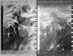


This morning a baby rabbit and a chicken escaped their houses, causing a chorus of exclamations like “Mira Mira!!” and “Rapido!!” from the group of small children playing around the farm. I had thought the site of me standing with an antenna in the garden would attract some attention, but the rabbits and chickens were far more important.
In this ten-day holiday I have been avoiding most news from the outside world, focusing on the immediate needs of rest, and conversations with T about the future- yet I have woken up most days having dreamed of Palestine. The Basque Country is full of symbols of Palestine solidarity, from 'Palestine aurrera!' to flags draped from seaside windows. Yet my dreams are full of the feeling that a draped flag or a scrawled sentence of support is far, far too little - has been far too little for too long.
I spend some of my time on this holiday building a Palestine geographies 'reader', an attempt, with two other geographers, one of them Palestinian, to make an open access, growing resource for thinking and remembering the expansive geographies of Palestine, including not only Gaza but the post-48 diaspora. I wonder if, like a draped flag, the role of this 'reader' will be symbolic, or if it will make possible other forms of reckoning and remembering. In 'A Map, the Sea, and Many Olive Trees', Elia Ayoub recounts how his grandfather was forced from his hometown in Haifa to Lebanon in 1948. He describes the systematic 'self-defencing' or obliteration of Palestinian settlements within and beyond Gaza, including importantly olive groves. "Many Olive trees are older than 1948. The Israelis must believe that these Olive trees have seen too much. Why else have they spent decades destroying them? Why do they still do it?".
Elia concludes the essay: "You grow up a little bit. You're 34 years/centuries old now. You're already older than many Olive trees because Israel has been cutting those down, you see. That makes you an elder. An elder is someone who is older than the Olive trees"
2025-08-16 20:13:33
Sasha Engelmann
Zumaia, Spain
Spain
NOAA-15
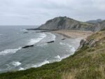
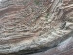
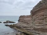
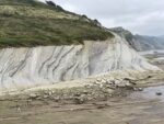
On the seaside earlier today, we observed a cliffside made of hundreds of striated rock layers. They followed each other closely, tracing back hundreds of millions of years in their gentle curves. One line was very thin and black, and represented the mass extinction event of 66 million years ago, during which 75% of marine mammals and other life forms perished. The layer was found to contain a very high amount of Iridium, otherwise very rare on earth, which corroborates the theory that a giant meteor caused the mass extinction. This is the meteor that fell in what is now the Gulf of New Mexico, creating the conditions for massive deposits of fossil hydrocarbons that are exploited by oil companies today. Though I was already convinced of the ‘fractal’ quality of such histories, whereby ancient ‘catastrophes’ spiral in self-similar yet changeable patterns into contemporary times, seeing the mass extinction event inscribed in striations of rock made this idea even more palpable.
2025-08-14 09:45:31
Sasha Engelmann
Zumaia, Spain
Spain
NOAA-15
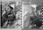


A lush green countryside of pines, vegetable fields and long grasses fades into the morning haze. One can barely make out the outline of a mountain ridge that must not be far away. A rooster has been crowing all morning, and a community of rabbits thump their hind legs, signaling inexplicable warnings to each other.
Zumaia is a small town in the Basque Country in northern Spain, situated in a ‘geopark’ with one of the worlds longest continuous rock strata. It is a landscape unlike any I have ever seen, sparsely populated, and made of sharp peaks rather than rolling seaside hills. August temperatures don’t reach higher than 28 degrees, despite heatwaves occurring nearby in France and inland Spain. It is as if the landscape is wrapped in a marine blanket that literally dampens temperature extremes, while making it difficult to dry a bathing suit from one day to the next.
NOAA 15's life has been 'extended' for around another week, but as I already said my 'goodbyes' in France a couple days ago, this extra time feels surreal - like a time warp or window that may collapse or stretch in unpredictable ways.
2025-08-17 08:26:28
Michele Boulogne
Amsterdam, The Netherlands
The Netherlands
NOAA-15

First colder day after an historic heatwave above Europe; Thought I would catch a bit of NOAA 15 from my balcony before the end. It's only 7 minutes but always quite magical to do.
2025-08-16 22:31:00
Zack Wettstein
Seattle, United States
United States
NOAA-19

2025-08-17 07:22:00
Maufox
Mauritius, Mauritius
Mauritius
NOAA-15

2025-08-17 09:42:00
Oppressive Heat Project
Phnom Penh, Cambodia
Cambodia
NOAA-19

2025-08-16 19:39:00
Zack Wettstein
Seattle, United States
United States
NOAA-15
2025-08-16 19:15:00
Heidi Neilson
Gilboa, New York, United States
United States
NOAA-15
2025-08-16 23:01:00
Foto Colectania
Hangar
Ràdio Web MACBA
Barcelona, Spain
Spain
NOAA-19

2025-08-16 08:18:15
Steve Engelmann
Venice Pier, United States
United States
NOAA-15
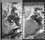

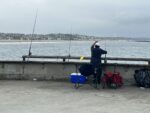


The summer in southern California has been unusually cool, and today was another rare overcast August morning. An anomalous high pressure system has been stationed over the northwest Pacific resulting in strong oceanic upwelling along the California coast. The cool water has a chilling effect along the coast. Not to worry, further inland, heat records are being set.
With NOAA 18 and 19 fading away, I was hoping to capture NOAA 15 passing over at 85°. I went to the Venice Pier with unobstructed views. The pier was busy on a Saturday morning with many recreational fishers casting lines. While there wasn't much of a swell there were surfers in the water and tourists enjoying the view.
2025-08-16 19:18:12
Alison Scott
Arbroath, United Kingdom
United Kingdom
NOAA-15


Another inside/ outside capture, this time poking the antenna out of the upstairs window. I've been outside a lot - if these notes make it seem I barely leave the house - and missed the other passes. The satellite is passing more to the east, so I'm on the other side of the house. It's a bit awkward, my arms get tired holding the antenna out beyond the building, swapping hands often and holding tight. The window sills are deep because of the old stone walls so I'm leaning quite a lot. Crows, seagulls and wood pigeons take turns at perching on the aerials across the road. There's a clear, cloudless blue sky and sun hits the rooftops. It makes the red sandstone glow a bright burnt orange. The storm has passed but until mid-afternoon the town was covered in a low cloud or haar that felt it could burn off any moment. When we were down at the beach, finding shell riddled hagstones and quartz veined pebbles, it was quiet. The sleepy feeling of early morning pushed through until the sun and the crowds came bursting out. It's the last weekend of the school holidays. I think I caught the sun on my face while cycling back along the coast. I'm quite happy to be inside now. We've had Joe to stay, who keenly remembered the satellite's sounds from working on a audio piece with me for an exhibition in 2021. It merged my daily recordings with extracts from personal weather diaries found in the Scottish Meteorological Society archives - made close to when I started listening to these orbiting bodies. Things (that) come back around. We talk about space junk. Archives. We have other conversations about silence, how it can be so loud, so felt.
2025-08-16 20:15:00
Maufox
Mauritius, Mauritius
Mauritius
NOAA-15

2025-08-16 17:03:00
Nastassja Simensky
Longyearbyen, Svalbard
Svalbard
NOAA-15

2025-08-16 18:35:00
Maufox
Mauritius, Mauritius
Mauritius
NOAA-15

2025-08-16 07:49:00
Maufox
Mauritius, Mauritius
Mauritius
NOAA-15

2025-08-16 09:54:00
Oppressive Heat Project
Phnom Penh, Cambodia
Cambodia
NOAA-19

2025-08-16 06:10:00
Maufox
Mauritius, Mauritius
Mauritius
NOAA-15

2025-08-14 19:45:03
Alison Scott
Arbroath , United Kingdom
United Kingdom
NOAA-15

Back garden NOAA-15 listen again. Sky a flat grey. Fairly still. Another break in the drizzle. Neighbour does pop out this time. 'Don't let me get in the way of your signal'. Surprisingly few questions.
2025-08-15 11:15:00
Zack Wettstein
Seattle, United States
United States
NOAA-19
