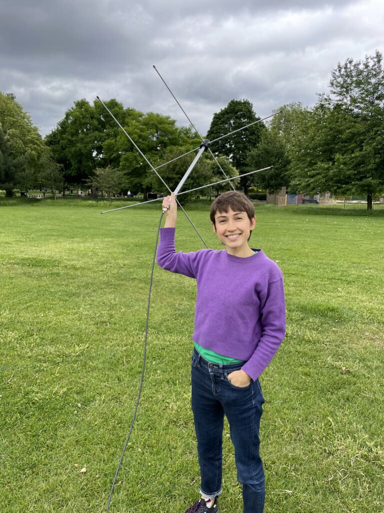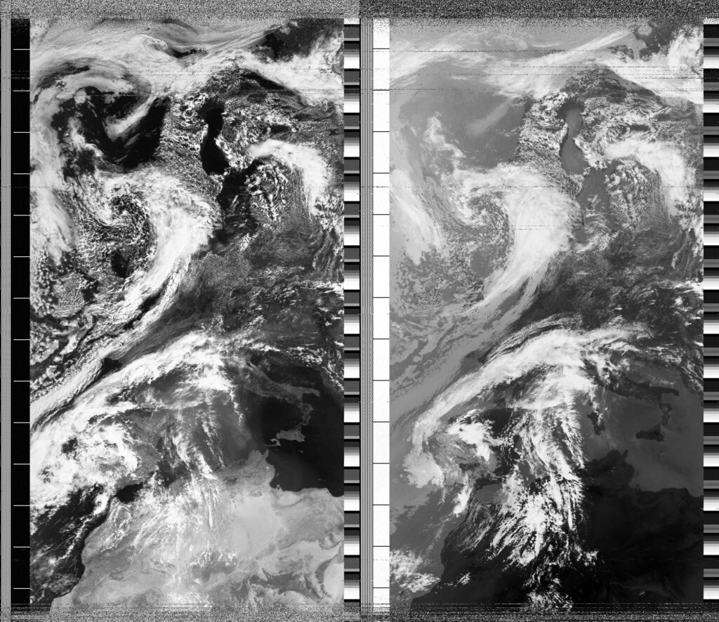
The air is warm but skies are grey, which has been a regular theme these last few weeks in London. A man named Rowan walked barefoot across the grassy field and introduced himself by saying "I think you can guess the question I'm going to ask you". We spoke for almost the duration of the pass, and he kindly took the attached photo of me. As I was explaining NOAA-18's Advanced Very High Resolution Radiometer and how it scans Earth's surface in six spectral bands, but only two of these six are represented in the APT image appearing on my screen, I remembered an article sent to me and Soph by Bill Liles (NQ6Z) that tells the story of Virginia Norwood, sometimes called the 'Mother of Landsat', who designed the Multispectral Scanner (MSS) on board the first Landsat satellite (Landsat-1) launched in 1972. Virginia famously worked with a team to invent a scanning instrument that used a mirror moving between two 'bumpers' at a rate that allowed precise scanning of Earth's surface. According to the article in the MIT technology review, Virginia worked hard to convince NASA and other scientists of the precision of the scanner, and many were sceptical of what they called the 'banging mirror' and how it would work in space. Learning of this history, and specifically the working of the MSS, made me wonder about the relationships between the MSS scanner and the AVHRR of the NOAA fleet. My guess is that early scanning instrument knowledge of the 60s and 70s was shared across NASA and NOAA teams, since these organisations are so entangled with each other and with defense operations. I do also know from previous research that the Automatic Picture Transmission common to most NOAA satellites was first tested in 1963 on TIROS-8, almost a decade before the MSS instrument was launched on the first Landsat satellite. The experimental APT transmissions from TIROS-8 used data from 'a five-channel scanning radiometer', but TIROS-8 also carried two TV cameras (images from these cameras were either transmitted directly to US ground stations when the satellite was in range, or stored on a tape recorder until transmission). A key difference between NOAA and Landsat programmes was purpose- since its formation in 1970, NOAA operated a fleet of TIROS-type weather satellites that were intended for meteorological uses, and so were relatively low resolution. According to NASA, the innovation of Landsat was to produce higher resolution terrestrial images of earth that could be useful to understand crop distribution or even geology, and would supplement the very high resolution of land captured from airplanes. Yet Landsat has further historical relations to NOAA. According to the Wikipedia entry on the Landsat Programme, "In 1979, President of the United States Jimmy Carter's Presidential Directive 54 transferred Landsat operations from NASA to National Oceanic and Atmospheric Administration (NOAA)". Under NOAA's tenure of the Landsat programme, prices for Landsat data soared, as NOAA sought to recover costs from users. This unfortunately led to a massive decrease in Landsat data, except for very powerful and resourceful companies like those in the fossil fuel industry (though we also know that the US government gave special access to satellite imagery for fossil fuel corporations at different points in history). Much like the three still-active NOAA satellites have recently been contracted to Parsons Corporation, the Landsat programme was also temporarily privatised. "This occurred in 1985 when the Earth Observation Satellite Company (EOSAT), a partnership of Hughes Aircraft Company and RCA, was selected by NOAA to operate the Landsat system with a ten-year contract" (Wikipedia). The transition to private maintenance was not smooth, and funds were very short, so in 1989 NOAA directed the shutdown of Landsat 4 and 5. The shutdown was averted by the US Congress, which shifted policy and found emergency funding for the Landsat programme, bringing it back under the control of the government and opening Landsat data once again for widespread use. This was a well timed rescue, since Landsat 6 failed during launch and crashed in the Indian Ocean. Like NOAA-15, 18 and 19, satellites that have remained active long passed their intended lifespans, there are similar stories in Landsat. According to a 2012 article by NASA, "Despite all of the ups and downs, Landsat 5 and 7 operated far beyond their designed lives. The Thematic Mapper (TM) on Landsat 5 only recently gave out after 27 years of imaging; around the same time as TM shut down, operators managed to turn the Multispectral Scanner System (MSS) back on after years of dormancy. Landsat 7 continues its work as well, 13 years after launch". Across NOAA and Landsat, then, there are some common stories of instrumentation, orbital patterns, attempts at privatisation and the longevity of the satellites themselves. As we prepare for the decomissioning of the three still-active analogue NOAA satellites, I'd like to go deeper into the interconnected histories of satellite programmes, scanning-instrument types and the different sorts of 'publics' they were intended to serve.
Date
8 June 2024 11:46:39Location
Hackney Downs, LondonCountry or Territory
United KingdomName
Sasha EngelmannSatellite
NOAA-18Radio Callsign
Latitute / Longitude